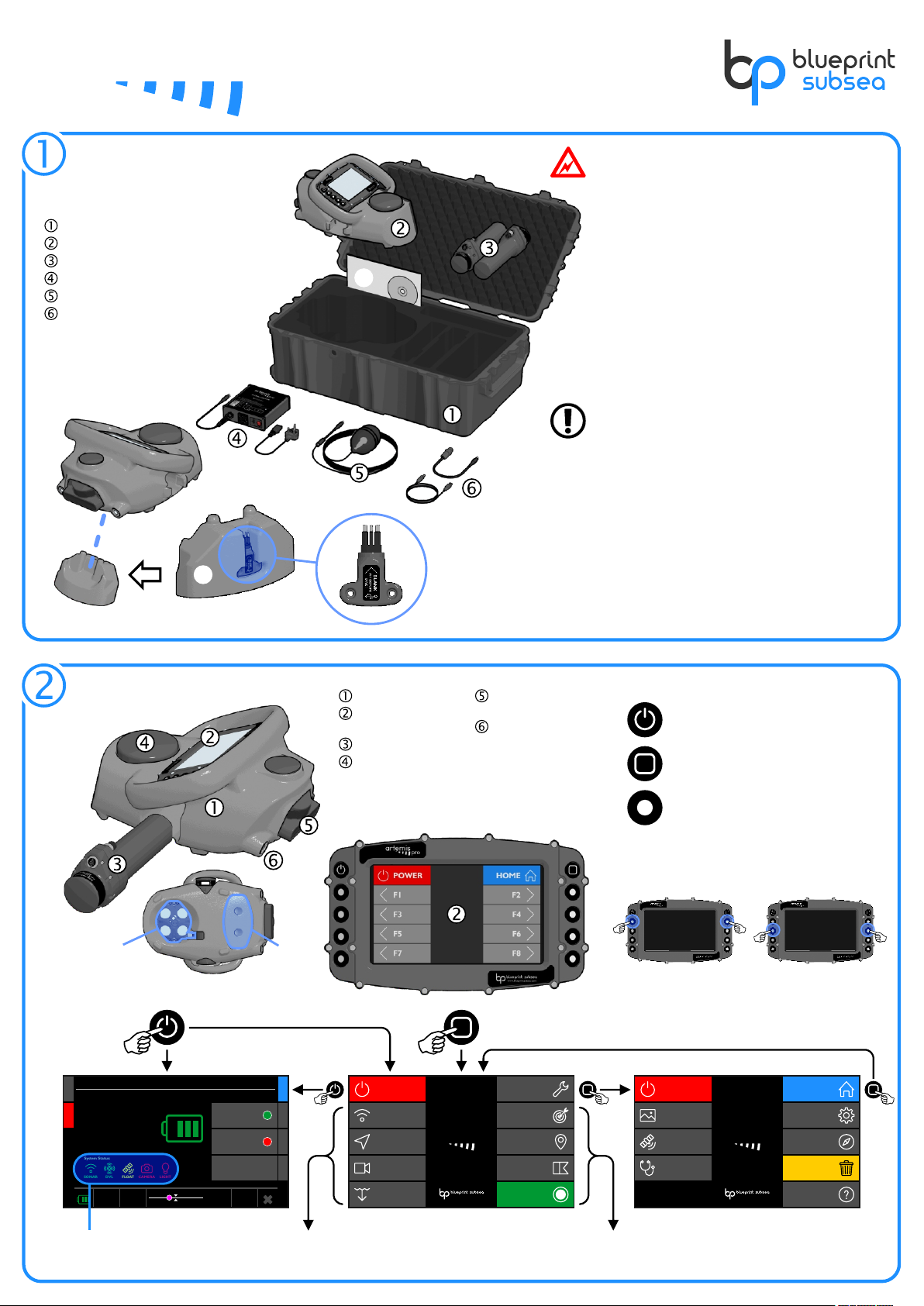
ˆ
CANCEL
Start Dive
Where are you starting the dive from:
A MARKER position or a SATELLITE position?
MARKER SATELLITE
CANCEL
Start Dive
Which MARKER are you starting from?
PREVIOUS NEXT
SELECT
-3° 2' 37.178" E
Longitude:
54° 13' 54.273" N
Latitude:
Waypoint 2
Name:
2 / 8
Marker:
CANCEL
Start Dive
Are you towing the float on the surface?
(and need continuous SATELLITE positions)
YES
(Towing Float)
NO
(Use Dead Reckoning)
CANCEL
Start Dive
Check sensor readings are good, then choose
START DIVE to begin recording the Dive-Log.
START DIVE
GOOD (37)
Quality:
RUNNING
Status:
POOR (3.5)
Quality:
Internal
Receiver:
Satellite PositionDVL
Has a
MISSION FILE
been selected
?
“START DIVE”
YES NO
“HOME”
MARKER
SELECT
SATELLITE
START DIVE
Data is recorded in the Dive-Log
and Navigation starts.
“STOP DIVE”
YES or NO
Power: DiveLog:
Waypoint 2
8.4m
Depth:
374m
Distance:
217°
Heading:
32.7m
Altitude:
Selected Marker:
P/N: BP01077.1A.5 UM-150-P01077-1A-05
Copyright © 2017 - www.blueprintsubsea.com
USING NAVIGATION
Compass Calibration
DIVING & DIVE-LOGS
Starting A Dive
Reducing Errors
Navigation Display
Chart Scale
(Zoom in/out)
Select Navigation Marker
(from selected Mission File)
Marker Manager
(Add, Select, Delete)
Set/Reset Position Clear Diver Track
WAYPOINT 3
WAYPOINT 5
MARKER 3
WAYPOINT 6
WAYPOINT 8
WAYPOINT 1
WAYPOINT 2 MARKER 4
MARKER 2
54° 13' 54.273" N
-3° 2' 37.178" E
Position:
10m
Grid:
DVL
Nav Mode:
Power: DiveLog:
Waypoint 8
3.1m
Depth:
58m
Distance:
23°
Heading:
4.9m
Altitude:
Selected Marker:
ZOOM + ZOOM - MARKERSPOWER POSITION
PREVNEXTDISPLAY HOMECLEAR
TARGET 3
TARGET 2
Level
(less than ±20°)
Not Level
(more than ±20°)
Good Altitude Reading
Poor Altitude Reading
Stable
(no Pitch or Roll)
Avoid Large or
or Quick Movement
(Pitch and Roll)
Calibrating Z-axis
(up and down)
Calibrating X-axis
(front and back)
Calibrating Y-axis
(le and right)
Measured Field and
Spherical Coverage
Ideal Result
CANCEL
Set Diver Position
Where do you want to set your position to?
MARKER SATELLITE
GOOD (0.3)
Quality:
Internal
Receiver:
Satellite Position
-3° 2' 37.178" E
54° 13' 54.273" N
Latitude:
Waypoint 2
Name:
Marker Position
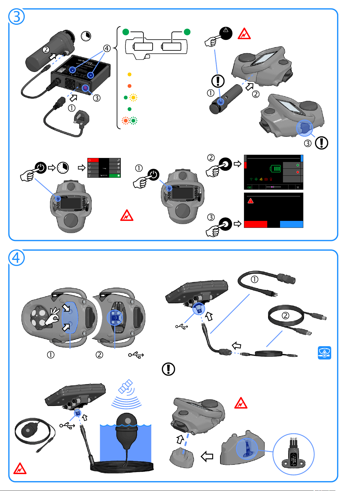
Choose “Calibrate Compass” from the Tools Screen - Press START to begin:
Hold ArtemisPRO in the six orientations
for each face of a cube.
For each orientation, rotate slowly on the
same spot in both directions.
Press PROCESS and ACCEPT
when complete.
Hold ArtemisPRO level:
Hold ArtemisPRO still:
Specify the Water Salinity in the Sensors menu of the Settings display
Calibrate the Compass before each dive to remove any magnetic errors
To reset the divers
dead-reckoning
position choose a
MARKER or use a
SATELLITE fix (from
the float, or return
to the surface).
Chart backgrounds are shown
if included in a NavPoint created
Mission File.
Replaying Dive-Logs
Ensure the internal Satellite receiver has a good fix
and a Mission File is selected if required.
Steps ƒ and „ allow the diver to choose the
starting location for dead-reckoning to track from.
At step … choose NO to use dead-reckoning.
Connect the external GNSS float (using the internal
GNSS receiver for continuous satellite navigation is
not recommended as larger position errors can
occur as the receiver is submerged)
At step … choose YES to allow satellite fixes to be
processed during the dive (even if a float isn't
connected).
Dead-Reckoning Dive Continuous Satellite Fix Dive
20%
Gain:
50m
Range:
750kHz
Frequency:
DIVE-LOGS RESETPOWER PLAY
HOME
Depth: 5.7m
Altitude: 6.2m
Diver:
Sat Nov 11 13:29:18
Mission:
WAYPOINT 3
WAYPOINT 5
MARKER 3
WAYPOINT 6
WAYPOINT 8
WAYPOINT 1
WAYPOINT 2 MARKER 4
MARKER 2
TARGET 3
TARGET 2
54° 13' 54.273" N
-3° 2' 37.178" E
Position:
10m
Grid:
DVL
Nav Mode:
Dive-Logs
1.
Current Dive-Log
Filename:
ArtemisPRO_20161105_093712
Mission File Used:
ArtemisPRO_20161018_114627
2. ArtemisPRO_20161021_130852
3. ArtemisPRO_20161103_092817
4. ArtemisPRO_20161105_093712
5. ArtemisPRO_20171108_144905
Power: DiveLog:
Waypoint 8
3.1m
Depth:
58m
Distance:
23°
Heading:
4.9m
Altitude:
Selected Marker:
SNAPSHOTSPOWER
SELECTDELETE HOME
Diver Training Area
Created:
2016-11-05, 09:37:12
Markers:
14
36%
Duration:
28m 15s
Size:
358Mb
Storage Used:
Move the list selection
up and down
Play/Pause Skip
±10%
Select Dive-Logs to replay in the Dive-Log Manager display: